


Oilfield Infrastructure at your Desktop.
Built for Operations.
GoOptz, powered by Elite Optimization, is a GIS-centric platform that harnesses the power of ESRI's geospatial technology to create a comprehensive hub for viewing detailed oilfield infrastructure remotely. It provides a detailed, accessible digital twin from any computer, integrating Drone Imagery, 360 walk-throughs, photos, GIS, KMZ, CAD, documents, inventory, and as-builts into a centralized layer. This enhances efficiency and decision-making by optimizing workflows and resources, helping you track assets, and supporting regulatory submissions to ensure compliance and facilitate strategic planning.


Powered By
Maximize Efficiency and Minimize Onsite Risk

GoOptz allows your team to conduct virtual site visits and gather mission-critical data from the office, dramatically reducing onsite hours and travel expenses.
GoOptz is a single source of truth, consolidating Survey, GIS, KMZs, Documents, Inventory, As-builts, Drone Imagery, and Photos into one central platform.
Teams can troubleshoot issues remotely and conduct planning and design work with confidence. Access to "good data" ensures decisions are grounded in reality, eliminating guesswork and preventing costly errors that arise from outdated or fragmented field information.
Tailored to Every Role That Keeps Your Operation Moving
Whether you’re managing field crews, designing infrastructure, or overseeing compliance, GoOptz delivers the precision, speed, and visibility your team depends on.
Survey-grade, geo-accurate mapping | Visualize tanks, pipelines, powerlines & more | Centralized dashboard for all field data | Streamline compliance & reporting |
Trusted by Operators.
Delivery with Accuracy and Speed.
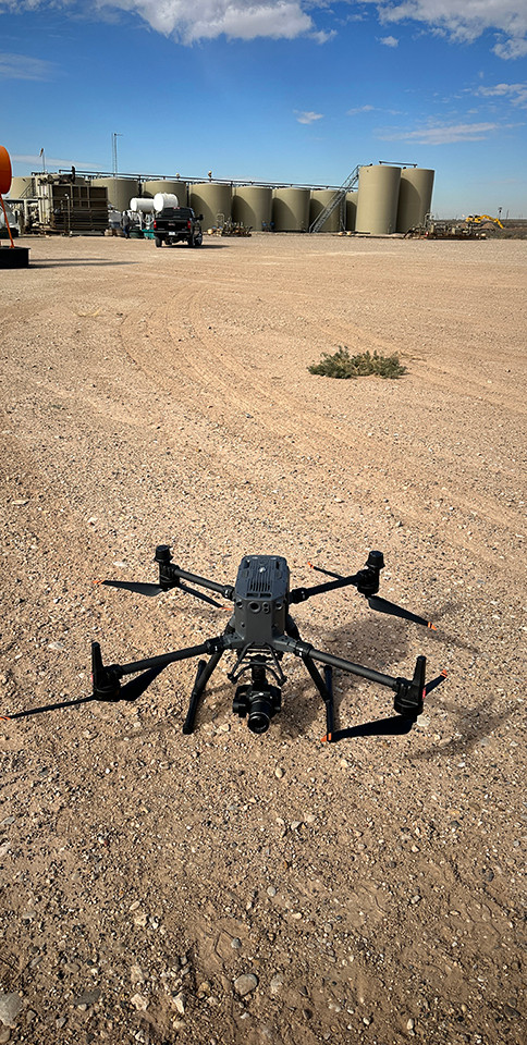
Our highly trained geomatics technicians and FAA part 107 Drone Pilots capture field data with speed and precision. Leveraging commercial drones, photogrammetry techniques, and ground control points, they execute comprehensive project surveys, including initial scouting, final as-builts as well as detailed tasks like open-trench as-builts and equipment inventories. By maintaining strict internal QC processes and adhering to FAA Part 107 we ensure all critical data, from high-resolution drone orthomosaics and 360° walk-throughs, is captured quickly, rigorously quality-checked, and immediately prepared for integration into the GoOptz platform.
GoOptz cut our planning cycle by 40% and improved accuracy across multiple teams. We can now make project updates and permit submissions in hours, not days.
Senior Project Engineer, Energy Firm
Finally, all our maps, permits, and layers in one view. It’s transformed how we plan projects.
Project Manager, Environmental Services
The accuracy is unreal. We trust what we see and we can make confident calls without stepping foot in the field.
Operations Supervisor,
Oil & Gas Operator
GoOptz
Unifying critical infrastructure data for operations in one central, easily accessible platform.


Value:
-
Reduced trips to the field
-
Up-to-date imagery and as-builts
-
Equipment details on demand
-
Mapped pneumatics for reporting
-
Asset inventory
-
A centralized hub, ensuring every stakeholder sees the exact same data
-
CVSAs made easy
-
Regulatory reporting made easy
-
Centralized operations reporting
Map:
-
High Resolution Drone Imagery
-
Upstream Facilities full equipment inventory with pictures
-
Pneumatic Device inventory for emissions reporting
-
360 Walk-Throughs
-
Pipeline as-builts and weld mapping.
-
Support for RRC T4 and 811 submissions
-
Powerline Infrastructure as-built and inspections
-
Geo-located Operations Reporting
-
Organize KMZs, shapes and CAD drawings
-
Collaborative Sketching Tool
-
Direct data stream to client GIS portal

Discovery
& Demo
We learn your current challenges and discuss the value GoOptz can bring to your operations.
Data Upload
& Field Survey
Our team will upload existing data and schedule data collection based on client objectives.
Dashboard Creation
& Integration
We personalize the dashboard with your company’s branding, data, metrics, and team permissions, making GoOptz feel like your own fully configured, central hub for your operations in just days.
Updates & Customizations
As your operation evolves, GoOptz evolves with you. We can provide ongoing updates, new data layers, and continuous optimization to keep everything live and current.
Data
Ownership
GoOptz gives you full data ownership, seamlessly streaming your data directly into your existing GIS infrastructure or equivalent systems. We handle the field collection, so you can bypass the manual work and focus purely on the value the data adds to your day to day operations.
From Demo To Deployment
Getting started with GoOptz is simple, guided, and surprisingly fast. Our experts work one-on-one with your team to customize, configure, and train you for success.
(Fully live in weeks, not months.)
Flexible Plans, Built for Every Operation
Every company is unique, that’s why GoOptz offers flexible tiers built around your data needs, team size, and growth goals. Pricing is customized to your operation’s scale, data needs, and number of users, ensuring you only pay for what you need.
Feature
Cloud-Hosted Interactive Dashboard - Client Branded
Scalable - Viewer or Editor Licenses
Public GIS Database Layers
Historic Data Import & Integration
Collaborative Sketching Tools
High Resolution Drone Imagery Raster
360 Walk Thru and Photo Layers
GIS Infrastructure Layers
CAD & PDF Layers
Geo-tagged Emitting Devices Inventory w/ Photos
Driving Directions Layer
Powerline Inspection Layer
SCADA Integration
Dedicated Success Manager
Direct Export to Client ESRI Environment
Project Use
✔
✔
✔
✔
✔
✔
✔
✔
✔
✔
✔
✔
✔
✔
✔
x
x
x
Enterprise
✔
✔
✔
✔
✔
✔
✔
✔
✔
✔
✔
✔
✔
✔
✔
✔
✔
x
Content Delivery
X
X
X
X
X
X
X
$$
✔
✔
✔
✔
✔
✔
✔
✔
✔
✔
Feature
Cloud-Hosted Interactive Dashboard
Scalable - Viewer or Editor License
Public GIS Database Layers
Historic Data Import & Integration
Collaborative Sketching Tools
High Resolution Drone Imagery Raster
360 Walk Thru and Photo Layers
GIS Infrastructure Layers
CAD & PDF Layers
Geo-tagged Emitting Devices Inventory w/ Photos
Driving Directions Layer
Powerline Inspection Layer
SCADA Integration
Dedicated Success Manager
Direct Export to Client ESRI Environment
Project Use
✔
✔
✔
✔
✔
✔
✔
✔
✔
✔
✔
X
X
X
X
Enterprise
✔
✔
✔
✔
✔
✔
✔
✔
✔
✔
✔
✔
✔
✔
X
Content Delivery
X
X
X
X
X
$$
✔
✔
✔
✔
✔
✔
✔
✔
✔
Lock In Your Onboarding Bonus
Book your personalized GoOptz demo today and receive a complimentary onboarding package designed to fast-track your implementation.
Included in Your Setup:
-
Free personalized demo
-
Personalized GoOptz configuration, built around your current workflows
-
Up to 10 team members onboarded and trained 1-on-1
-
Custom dashboard branded for your company
-
Dedicated success manager to guide your rollout
-
Full implementation roadmap from demo to deployment
Book your demo now to lock in this onboarding package before our new pricing updates for upcoming feature releases.
*No payment or commitment required, this simply reserves your rate when you book a demo.
Here's what changes with GoOptz
Before:
-
KMZs hand-drawn in, unreliable, and approximate.
-
Outdated pixelated basemap. Satellite imagery can’t keep up with the development in the Permian.
-
Lost field photos, lost CAD drawings, survey plats, KMZs and shapes getting stuck in emails, drive folders or shared files.
-
3rd Party service reports that get lost or aren’t being completed. They aren’t standardized.
-
Trying to keep track of inventory and device reporting in excel files.

After:
-
True geo-spatially accurate data.
-
High-resolution, geo-spatially accurate drone imagery that you can measure off of.
-
A geo-spatially accurate way to organize your pictures and files on a map with a data point that supports attachments showing that data where it is in the world.
-
A workflow to manage 3rd-party service reporting that allows you to see all the reports for a given location in one spot and run statistics on them.
-
Geo-spatially accurate data points that are fully attributed with photos which you can filter, run reports on an export as needed.
%20copy_edited.jpg)


FAQ
Diverse solutions tailored to your every need
That’s exactly why GoOptz exists.
Our onboarding team helps you pull in every dataset, even messy spreadsheets or legacy files and clean it automatically. Once centralized, your data stays live, synced, and version-controlled forever.Absolutely. GoOptz runs on 256-bit encrypted cloud infrastructure with redundant backups and role-based permissions. Every user sees only what they should, every action is logged, and your infrastructure data is protected just like a bank protects transactions.
Yes. GoOptz is built for enterprise-scale oilfield operations, from single-site producers to multi-region operators. The platform scales instantly and keeps performance lightning-fast, even with thousands of assets and map layers.
Not at all. GoOptz was designed so any operator, engineer, or project lead can use it. If you can navigate Google Maps, you can master GoOptz, no GIS degree required.
Most customers report:
-
30–50 % faster planning cycles
-
Major reduction in field errors and rework
-
Full visibility across departments in real time
In short: less guessing, less chaos, and fewer costly surprises.
-
Yes. GoOptz is fully mobile-optimized. Your crews can view, update, and annotate maps from any connected device.
No more waiting for data to trickle back to the office. Field and desk stay synced instantly.Every account comes with a dedicated success manager, unlimited live chat support, and ongoing product training.
We don’t disappear after setup either. We partner with your team to keep your maps, data, and people aligned.We’ll walk you through a live, customized tour based on your actual field data (or a similar oilfield project).
You’ll see exactly how your infrastructure will look, how the system works, and how fast it can be implemented.
You’ll walk away knowing timeframes, costs, and ROI, no fluff, just proof.We’ll walk you through a live, customized tour based on your actual field data (or a similar oilfield project).
You’ll see exactly how your infrastructure will look, how the system works, and how fast it can be implemented.
You’ll walk away knowing timeframes, costs, and ROI, no fluff, just proof.We’ll walk you through a live, customized tour based on your actual field data (or a similar oilfield project).
You’ll see exactly how your infrastructure will look, how the system works, and how fast it can be implemented.
You’ll walk away knowing timeframes, costs, and ROI, no fluff, just proof.We’ll walk you through a live, customized tour based on your actual field data (or a similar oilfield project).
You’ll see exactly how your infrastructure will look, how the system works, and how fast it can be implemented.
You’ll walk away knowing timeframes, costs, and ROI, no fluff, just proof.We’ll walk you through a live, customized tour based on your actual field data (or a similar oilfield project).
You’ll see exactly how your infrastructure will look, how the system works, and how fast it can be implemented.
You’ll walk away knowing timeframes, costs, and ROI, no fluff, just proof.We’ll walk you through a live, customized tour based on your actual field data (or a similar oilfield project).
You’ll see exactly how your infrastructure will look, how the system works, and how fast it can be implemented.
You’ll walk away knowing timeframes, costs, and ROI, no fluff, just proof.
See GoOptz in Your Operation
Experience your own data, workflows, and reporting, all live in a personalized demo. Discover why operators, engineers, and environmental teams are choosing GoOptz as their on-demand GIS solution.
Maximize your team's efficiency: Learn how top operators use GoOptz to centralize their data, eliminate field trips, and boost productivity from a single platform.